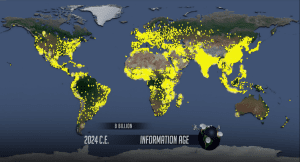
Places where people live, areas referred to by geographers as the ecumene, are referenced throughout the AP Human Geography course. The World Population “dot” video, and accompanying WorldPopulationHistory.org website, are a wonderful resource for exploring the ecumene through geographic population data.
What is the Ecumene?
 The ecumene is land that is permanently inhabited by humans. The ecumene can be explored at different scales – at a national scale, regional scale, or globally.
When students watch the World Population “dot” video in APHG’s unit 2, they’ll be introduced to the ecumene at the global scale.
What Makes Ecumene Areas Livable?
People live in areas where they are able to survive and thrive. The ecumene areas on Earth have a few things in common:
- Climate: The ecumene has a climate that can be survived by humans, whether with assistance or not (think substantial shelters, heating and cooling, proper clothing, etc.). The climate of the ecumene also must make agriculture viable.
- Resources: Linked closely to climate, these are the resources on which humans rely. The ecumene can be inhabited because people are able to access food, water, timber, and everything else they need.
- Geographic Features: The topography of the ecumene is suitable for building structures, planting crops, raising livestock, creating infrastructure, and moving from place to place.
Too Dry, Too High, Too Cold, Too Wet
What about areas that are not the ecumene? These places are typically harsh physical and climatic environments where it is difficult, if not impossible, to grow food and access other necessary resources. Non-ecumene areas are too dry, too high, too cold, or too wet for people to inhabit permanently.
Ecumene Areas Represented in the “Dot” Video
For APHG Unit 6, the CED requires students to understand “The presence and growth of cities vary across geographical locations because of physical geography and resources” (PSO-6). Refer back to the “dot” video. Areas with dots are the ecumene – they are areas where people permanently live. Areas without dots are non-ecumene.

Then head into the interactive map at WorldPopulationHistory.org – an annotated map of the same population data. Here, you can zoom in to explore ecumene areas to the regional or national level; as you zoom, the dots will separate to show a more precise location. This is especially helpful in areas that are densely populated and look painted yellow in the video.
Land Use Overlay to Explore the Ecumene
Another way to explore the ecumene is using the Human Land Use overlay on the interactive map found at WorldPopulationHistory.org. The overlay colors the map according to the type of land use with data starting in 1700. You’ll see colors for dense settlements, villages, rangelands, seminatural lands, wildlands, and croplands.

In 1700, the majority of Earth is seminatural land and wildlands. As time progresses, human land use changes dramatically. We see an obvious increase in agriculture (cropland and rangeland) and settled areas. What doesn’t change all that much, are the non-ecumene areas of wildlands. Areas like far northern Canada (too cold) and central Australia (too dry) were inhospitable in 1700 and for the most part, remain inhospitable today.
To find the overlay, select Human Land Use from the “Overlays” dropdown. It can be helpful to toggle the population dots on and off (using the “Map Features” dropdown) to more easily see the land use changes on the map.


