Resource Overview
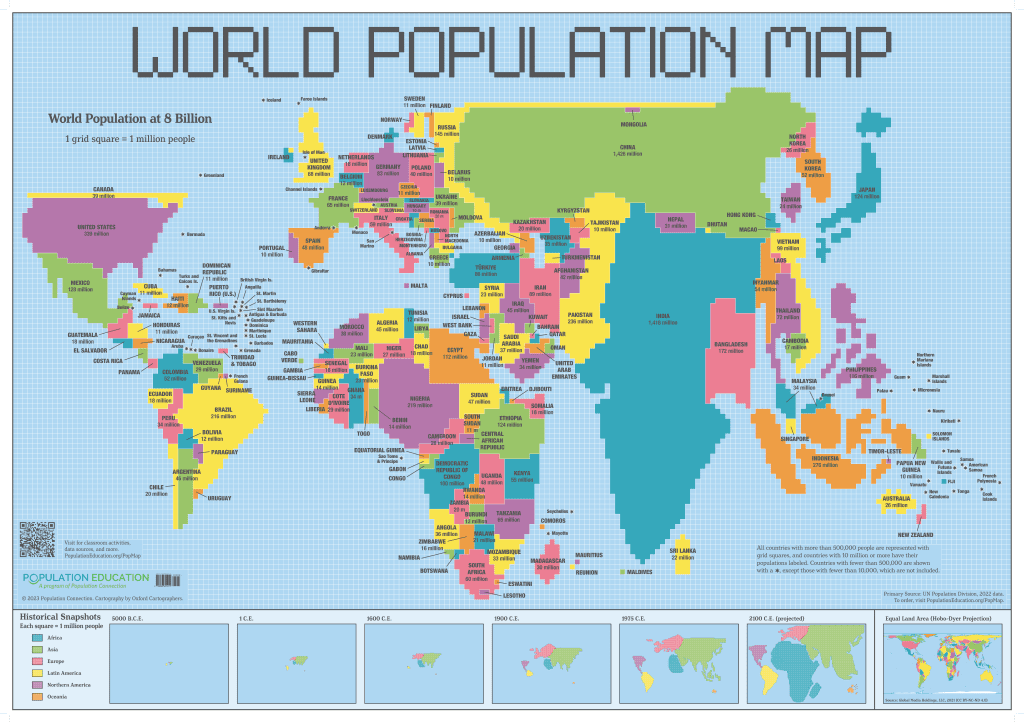
This lesson plans linked below accompany the World Population Map, a population cartogram.
Population Squared is an introductory activity that ensures students understand the cartogram and how it differs from traditional land area maps. Land Use Squared explores urbanization and arable land as they relate to population size. Other Population Education lessons are listed below that will further your students’ understanding of cartograms and demographics.
These activities are scalable for middle and high school classrooms. The content focus is social studies but all are interdisciplinary, relying on and applying knowledge and skills from mathematics and English language arts.
Features of This Resource
- A set of classroom activities that use the population map as a launch pad for student exploration of global demographics.
- Helps students understand and illustrate complex data and then extend their thinking to what this data means for the lives of people around the globe.
- Aligns with the C3 Framework – in particular, the Disciplinary Concepts and Tools for Geography, while emphasizing skills in developing compelling questions, developing explanations and making and supporting arguments, and critiquing and communicating conclusions.
- Students must effectively communicate their ideas through writing, discussions, and class presentations, addressing several English Language Arts/Literacy Common Core State Standards.
CARTOGRAM LESSON PLANS AND READINGS
Lesson Plans
Population Squared
-
Students analyze, interpret, and evaluate conclusions on population data from the World Population Map, and then construct their own population
Land Use Squared
-
Students compare the World Population Map with an equal area map to calculate statistics related to urbanization and arable land.
Readings
Mapping Population
-
Overview of population cartogram: what is it, when it's used, and limitations.
Lesson Plans
Population Squared
- Students analyze, interpret, and evaluate conclusions on population data from the World Population Map, and then construct their own populationLand Use Squared
- Students compare the World Population Map with an equal area map to calculate statistics related to urbanization and arable land.Readings
Mapping Population
- Overview of population cartogram: what is it, when it's used, and limitations.Supplemental Materials

How Do I Get This Lesson Packet?
The resource is free. Click the green button for immediate download. Download Now
Nice to meet you!
Tell us a bit about yourself so we can continue creating resources that meet your needs.
You’ll only need to fill out this form once. If you’ve already completed the form, you can confirm your email here.